Flying Home from Florida · · PAGE 196.
November 13, 2005: I had originally planned
on some low-level sight-seeing as I flew over the Leesburg and Ocala areas since I had
lived in this area back in the 1980's. The low-layers of clouds changed my plans and
I altered my course just after I took the last two photos on the previous page. When
I deleted the extra waypoints from the GPS, the course direct to my planned fuel stop took
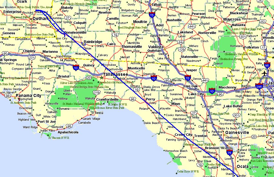
me directly across the Ocala airport, directly over Perry, Florida, and into the Wiregrass
area of southeastern Alabama. My planned fuel stop at Headland, Alabama was a bust.
Instead of the fuel price that was published on airnav.com, I discovered the pump
price was $3.88 instead of $2.99 for a gallon of 100 low-lead avgas. I flew back to
the Donalsonville, Georgia airport (17J)
where the price was $3.14 per gallon.
One of the interesting things about going over to Headland and then back to
Donalsonville was noticing that I had passed through a cold front that did not have any
associated rain. There was a cloud bank that I passed under as I descended toward 0J6 at Headland. It was quite cool when
I climbed out of the cockpit at Headland. The wind was out of the East, coming from
the high-pressure area to the low pressure front that was moving down from the northwest.
As it turned out, I did not get off the wing of the airplane when I pulled up to
the wrong fuel pump at Headland. A guy had just finished washing a Cessna 152 where
I pulled up next to a 100LL fuel tank. He pointed me toward the
"commercial" fuel pumps over to the East side of the ramp. I got back in
my seat and taxied over there to find the $3.88 per gallon price sign. At that
point, I did not even shut down the engine, but merely secured my safety belt and shoulder
belts for a short flight back to Donalsonville.
A Cessna Cardinal was in the run-up area near the north end of the runway at
Donalsonville when I landed. As I taxied to the ramp, I was again facing a choice of
two fuel pumps. Only one had a credit card reader and it also had the price I had
seen online posted at the pump. I topped off the tanks and took a short break before
calling Macon Flight Service on my cell phone. The radar picture described to me
north of the Atlanta area was not a good omen for the prospects of getting home. As
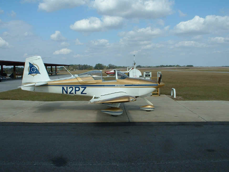
you can see from the photo above, the weather in south Georgia was excellent!
As I began the last leg of my flight home, I looked at the clouds and the
weather front off to the northwest of my position. I was joking with the guy at the
Macon Flight Service Station when I was on the phone that I might be coming to see him
face-to-face for another weather briefing on Monday morning after a layover in Perry,
Georgia if I had to wait out the weather front passage. It was during that earlier
phone call at Donalsonville that he had been describing level-three rain showers and
high-level icing conditions above 12,000 feet MSL near and north of Chattanooga.
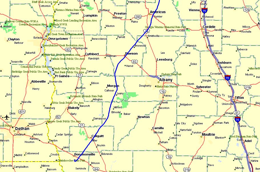
You can tell by the track below that my decision process about where I was
going was not finalized at the time of my departure from Donalsonville. As I passed
near Morgan, Georgia I thought about the possibility of flying in to see another RV-9A
builder/pilot who has a grass strip near Lumpkin, Georgia. What I was seeing out the
windshield changed my mind and I resumed my heading toward Perry, Georgia south of the
Macon area. I was also monitoring Atlanta Center radio traffic and hearing
conversations that led me to believe the weather was getting better north of Atlanta.
I called Macon Flight Service on the radio and discovered the mess on the WEST side
of Atlanta was still bad enough to head for the EAST side of Atlanta. I figured if I
could not get all the way home, I could probably make it to the Gwinnett County Airport (KLZU). My sister lives near there and
so does another friend and airplane builder who wants to see my airplane. With the
new weather information and the options of two places to spend the night, I altered my
course away from the Macon area and directly toward KLZU.
When I reached the south side of the Atlanta area Class B airspace, I called
the approach controller and got a squawk code for my radar transponder and told him my
plan to skirt the edge of the Class B airspace until I could check with flight service on
the weather again. Looking at the map below, you can see my course near the bottom
of the photo is directly toward Lawrenceville until I passed Conyers, Georgia. That
was when I completed my radio call to Macon Flight Service again and discovered that the
line of rain showers observed earlier near home had dissipated. I advised Atlanta
approach of my destination change and continued around any Class D airspace at
Lawrenceville and Peachtree-Dekalb Airport (KPDK).
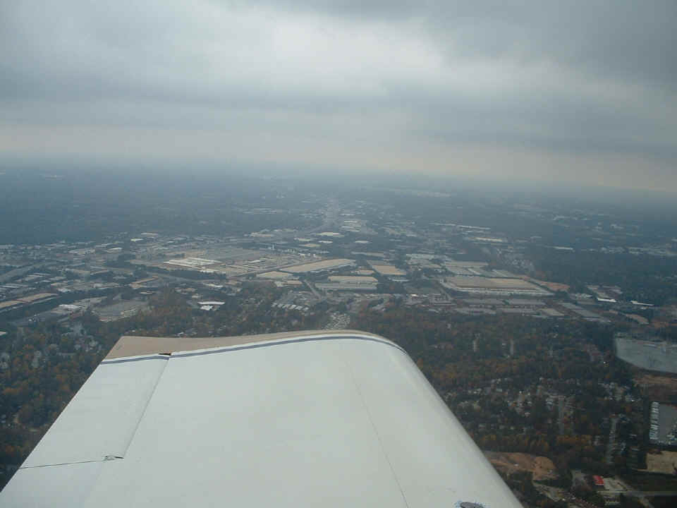
By the time I crossed Interstate 85 northeast of Atlanta, the clouds were
getting lower. The approach controller asked me if I wanted to climb to 3,500 feet
and I declined his request since I could not remain in VFR conditions. The view
below off my LEFT wing looking toward the intersection of I-85 and I-285 tells the story
of the low cloud cover and how it is getting lower ahead of me toward the RIGHT side of
the photo. I was watching my airspeed because of the possibility of turbulence in
the area. I saw that I was flying around 175 MPH true airspeed while the GPS ground
speed was 195 MPH. Since the turbulence was not really there, I kept going,
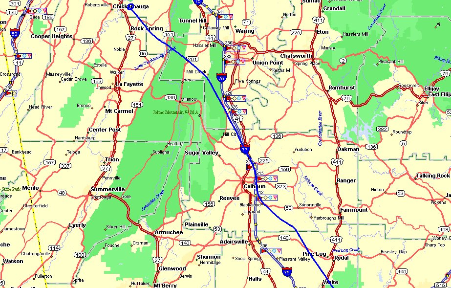
expecting to have to turn back for Lawrenceville at any time. Looking at the map
above, you can see where I altered my course twice to get into areas that had more ground
clearance below the overcast. Those areas were fairly easy to find since they
appeared "brighter" out the front of the windshield. I even flew through
one area of light rain/mist while I remembered the words of my flight instructor from 1992
back in Florida: "If you can see through it, you can fly through it."
That is just what I did!
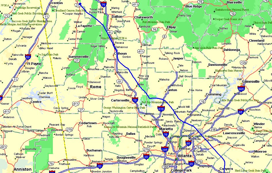
By the time I had passed the light rain/mist described above, I was passing the
line of low mountains that define one side of the valley where I grew up as a boy.
In fact, when I was discussing the weather with the controller in my phone call from south
Georgia, I thought about how much I knew about the lay of the land here, the valleys and
the mountains in my home area of North Georgia. When you look at this map, US 411 is
at the eastern side of the valley and the west side of the valley is near the US41/I-75
corridor just east of the green forest area near Sugar Valley. If you follow my
route of flight, you will see a little place named MILL CREEK. There is a gap in the
low-mountains there which was open below the overcast. I cleared the ridge with
plenty of room to spare and flew into clearing weather to the west of the gap. By
the time I flew over Folks Field, the sun was making an attempt to shine through the
overcast.
I flew over the field and noticed the wind sock standing straight out from the
south wind that had pushed me along since I was north of Atlanta. I circled around
again and made my approach from the north over the power lines and touched down on the
grass in front of the hangar. I stopped easily in the smooth area of the runway and
taxied back to the hangar. It was about 3 PM Eastern Time when I taxied up to the
hangar at Folks Field. I moved Wendell's Aeronca Champ out of the way and put
Enterprise back in the corner of the hangar. I called Macon Flight Service to thank
them for their assistance today and getting me home safely. The guy on the other end
made a computer record of the call and mentioned my other call and radio contacts that had
also been logged. It is good to know how to "work the system" when weather
is an issue. I did not have a flight plan to close with him since I really did not
expect to fly past Macon when I departed Donalsonville. I was never blocked by
instrument meteorological conditions (IMC) and therefore was able to complete my flight by
visual flight rules (VFR). It was a good day to get home, since the weather today
(Monday) would have kept me away from the Chattanooga area. It is still foggy and
misting outside at 4 PM as I write this.
The summary of the flights this weekend are posted below with Hobbs time for
each log entry:
Folks Field to Ocala, Florida (KOCF) - - - - - - - - - - - - -
2.7 hours
Ocala to Zephyrhills (KZPH) to Kissimmee (KISM) - - 1.1
hours (fuel at KZPH)
Kissimmee demo flight for Darren - - - - - - - - - - - - -
- - 0.9 hours
Kissimmee to Headland (0J6) to Donalsonville (17J) - - 2.4 hours
(fuel at 17J)
Donalsonville to Folks Field (home) - - - - - - - - - - - -
- - 2.0 hours
The total flight time for the weekend trip to central Florida and back home is
9.1 hours with a GPS ground track of 1,364 statute miles. That brings the Hobbs
meter to 133.7 hours for N2PZ since the first flight on June 9, 2005.
It was a weekend of tailwinds and some good experience with weather and Flight
Service Station assistance. The day I landed from my private pilot check ride (March
26, 1993), the examiner signed my pilot log book and gave me my temporary certificate and
told me "Now you have a license to learn." That is what I have been doing
on every flight since then.
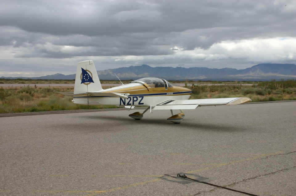
November 15, 2005: I was browsing Doug
Reeves' Van's Air Force web site this morning and found this picture taken during my arrival at LOE5 back on October 14th. This photo was taken by
Michael White as I was pulling onto the ramp to the tie-down area. The Franklin
Mountains are in the background and give you an idea of the overcast conditions that
greeted us when we flew past the Guadalupe Mountains all the way to our destination here
at the Dona Ana County Airport near Santa Teresa, New Mexico.
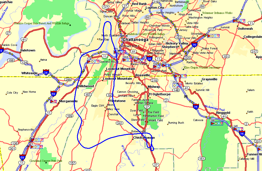
November 19, 2005: EAA chapter
150 had a fly-in breakfast this morning at the Collegedale airport. I was scrambling
eggs and washing dishes as one of the volunteers. David Schorr came by for a bit of
breakfast and then followed me home to Wendell's airport to get a ride in my RV-9A.
Flying young eagles today did not work out since some of the boy scouts were ill with the
flu apparently. I had originally offered David a ride from Wendell's air field back
to Collegedale when I thought I would be flying the young eagles. The flight turned
out to be just from Folks Field up and over Lookout Mountain and around it. The GPS
ground track for the 30-minute flight is shown below.
As I publish this update on Sunday evening, I am checking the weather for the week
ahead for a planned flight to South Florida. I have several RV internet friends who
want me to drop in down there with my airplane. I have friends at a company where I
worked that I also look forward to seeing once again. This time I have to remember
to take along the trophy and photo from LOE5.
November 25, 2005: This
update is posted via dial-up access from Florida. Tuesday morning (Nov 22nd) found
fair weather for a planned flight to Florida, but the weather outlook for the return home
date was BAD! So, paying attention to the old saying "Time to spare? Go
by air!" made the decision to drive the 12 hours to south Florida an easy choice.
IF I had flown down here instead of taking my car, I
would have been stuck somewhere away from home until probably December 2nd. The
drive down had one delay on the Florida Turnpike due to an accident in the southbound
lanes before reaching the Orlando area. I got off as many others did to find the
alternate route (US 27) to be backed-up as a result of the detour. I was glad to
have my Garmin 296 in AUTOMOTIVE mode and street maps programmed into my 128-megabyte
memory chip. I found a couple of county roads that got me out of the long line of
traffic on US 27 and cut my delay time to around 30 minutes instead of what could have
been an hour or more.
On Wednesday, I had a chance to see some old friends at a company where I
worked during the 1990's and made my 1 PM appointment to have my teeth cleaned at my old
dental office in North Palm Beach. Turkey Day went as planned with too much food
consumed as usual. Tomorrow is the day I get to meet two local RV-9A builders in
Broward County. I should have some photos to add to my "Other RV" section
of this web site after that visit is completed. I have also arranged to see another
RV-9A builder in Alabama on my way home. That meeting should be Monday evening,
November 28th. Stay tuned for more updates on this RV-trip to south Florida (without
the airplane). At least I get to meet other builders!
November 27, 2005: I posted some new pages
in my Other RV section of this web site. I visited two RV-9A builders yesterday in
Broward County near Fort Lauderdale. I have plenty of new photos of their projects
for your inspection via the OTHER RV MENU page. The
new pages are linked from the first two entries at the top of the menu.
November 30, 2005: I returned home from
Florida via car yesterday after a detour to Alabama to see Paul Rose, an RV-9A
builder. I have some photos I took in his shop and some he had emailed to me
previously POSTED on this page in the OTHER
RV section of this web site. I also stopped to see an old college friend and
business acquaintance in Andalusia, Alabama before turning toward home yesterday.