October 2009 · · PAGE 312.
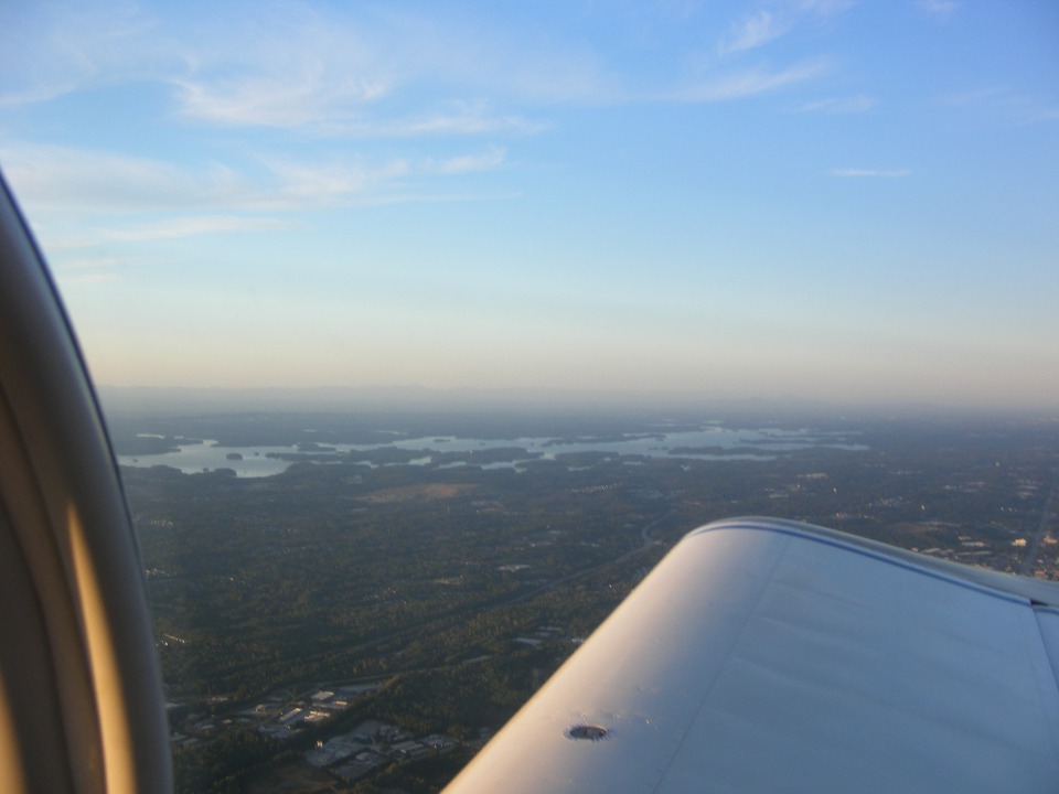
October 3, 2009: I took this photo at 6:54 PM when
I was cruising at 4,500 MSL and looking at Lake Lanier. It is the water supply for
most of Atlanta. The lake was full again after the recent flooding rains.
During the worst part of the drought in December 2007, it was down over 20 feet from the
full level.
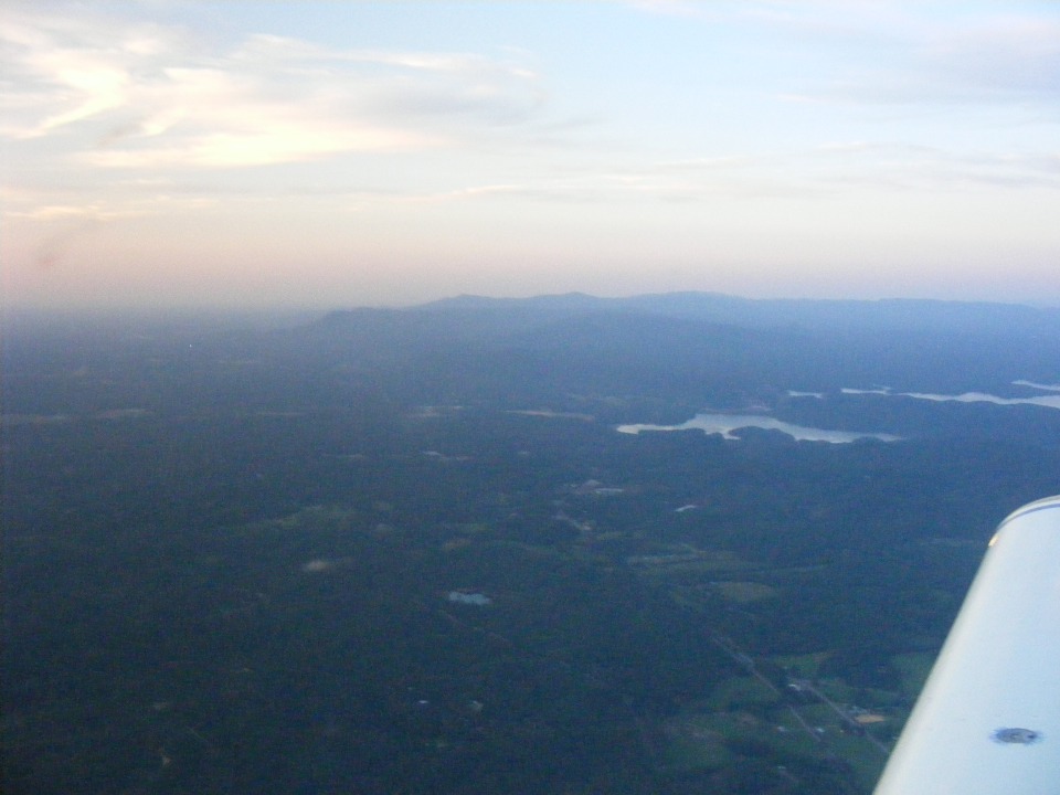
Here is a view of Carter's Lake and the mountains near Chatsworth, Georgia as I
looked north at 7:13 PM. Notice there is no direct sunlight on the wing in this
photo as there was in the picture above taken about 20 minutes earlier.
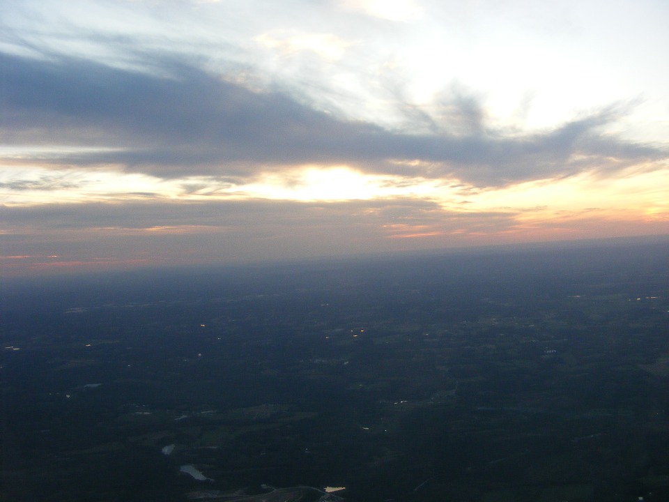
The photo below, taken about one minute later, shows the clouds obscuring the
setting sun to the west. The GPS was indicating my arrival at Folks Field for 7:30
PM. The GPS was still predicting sunset at 7:23 PM. I had a 10 MPH headwind
from Lawrenceville on this route to the northwest. I had pushed the RPM up to 2400
and 24 inches of manifold pressure for a fuel flow of 8.5 gallons per hour for this final
flight leg of the day. The total route covered 734 miles in seven flight segments.
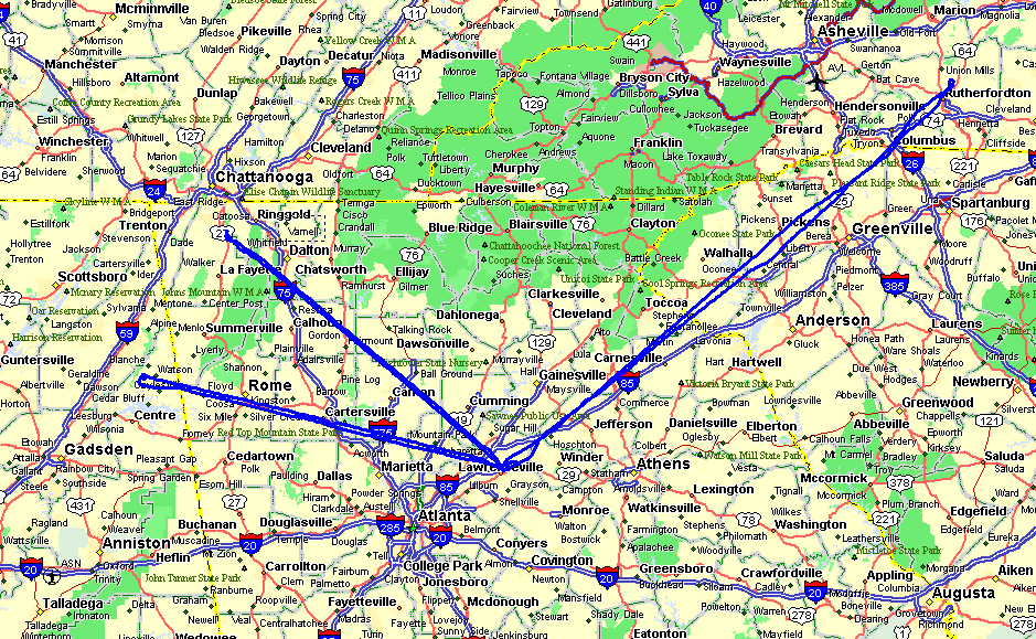
Here is the map showing the flight paths for today's journey. I landed at
Lawrenceville Airport three times today. The arrival at Folks Field was at exactly
7:30 PM per the time on the GPS. Wendell was out by the hangar waiting for me.
He figured I got stuck talking with someone before I took off for the final
leg. I told him about meeting William Huch and his wife just before my departure.
October 4, 2009: The only thing to do this
Sunday was clean all the bugs off the airplane after lunch. There was a solid
overcast today. It took about two hours to clean the airplane before I left the
airport to complete some of my other weekend chores. There is a light rain falling
as I publish this page after midnight on Sunday/Monday.
The next fly-in lunch is set for Saturday, October 24th at Rhodes Field southwest of Cartersville, Georgia. The LOE 2009 fly-in at the Dona Ana Airport in New Mexico is set for next Friday and Saturday, October 9-10. It is too far away to go this year with the budget I have. I went to LOE5 (2005) and brought home the trophy for the best RV-9A from that trip with Doug Reeves and his friends from the Dallas-Fort Worth Area.
October 11, 2009: Sunday morning and time for the weekly web site update. Yesterday was another day of low clouds and overcast. I went by the flying field in the morning to pay Wendell for the case of Aero Shell 100W Plus motor oil and two oil filters. I also had a short visit with the usual Saturday gang of local friends and pilots. There was no interest in going flying due to the low ceiling in the valley. The top of Lookout Mountain was obscured by clouds. Since the top of the mountain rises to about 2,100 MSL, and field elevation is around 760 MSL, that leaves about 1,300 feet of vertical space for flying. Just going around the pattern is a waste of fuel.
The weather for today may turn out better, but that remains to be seen after the morning sun does its thing with the low-hanging clouds over Chattanooga that I see looking out the window. If it is an inside day, there are enough chores to be done to pass the time and get things done. Only one day in the past week was "good" weather. Speaking of that weather, LOE 2009 was not well attended this year due to the bad weather. Even Doug Reeves, the MC for the event, had to fly commercial to El Paso to get there, leaving his airplane at home in the Fort Worth, Texas area. Those RV's flying in from the western states had good weather. There were over 30 airplanes on the ground at the event on Friday evening.
On the lighter side, my new passport came in the mail this past week. I am now ready to go places beyond our borders when needed for my day job. If I were taking my airplane out of the USA, I would also need to get a radio license from the Federal Communications Commission (FCC).
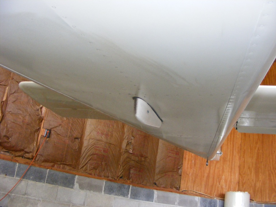
SUNDAY EVENING UPDATE: I went out to the airport today and spent more time completing the cleanup of the underside of the airplane. I had seen the flaps were in need of cleaning last Sunday. I went there today to do just that. As I lay down on the creeper with pillows under my head, I realized the bottom of the fuselage has been neglected after each of the last series of short flights. I stopped cleaning, grabbed the camera, and took this photo to show how a thin film of oil vapors and some dirt had darkened the underside of the fuselage. The upper right corner of the photo shows the freshly cleaned area that convinced me to take this photo before cleaning the remainder of the fuselage belly and tail cone.
I was joking with Wendell when he arrived about how I probably just added 5 MPH
to my cruising speed by using my "furniture polish" cleaner on the bottom side.
I even cleaned the wings and got some grime off of them. The left flap always
got more dirt and bugs than the right flap due to the direction of propeller rotation.
I can say that both of the flaps are clean tonight. The leading edge of the
fiberglass cover over the 75 MHz marker beacon antenna got my attention when I was
cleaning the main landing gear legs and the under side of the wing ahead of the main wing
spar. All that dirt on the front of that "boat" is now gone as well as the
darker section all the way back to the rudder.
The weather was great for flying today, but that was after I finished cleaning the airplane. After getting in 5.8 hours last weekend, I figured I would let this flight opportunity pass me by and keep the 27 gallons of fuel in the tanks.
Before we parted company, I reminded Wendell of a fly-in about 50 miles to the south scheduled for October 24th. He also told me that the SWRFI Fly-in scheduled for Casa Grande, Arizona his friend from Fort Payne had been considering is now off the schedule. He has to fly for the "boss" that weekend as part of his day job.
I also spoke with David Edgemon again today when I realized I had not asked David what color he was painting his RV-8. When I called him from John Myers airport last weekend, David told me he was painting the airplane. He told me today that he is doing a World War II P-51 paint scheme, complete with "Invasion Stripes" on the wings. He called it his "Walter Mitty fighter plane." He also mentioned that he is hosting the Tennessee Valley RV Builders Group (TVRVBG) meeting this coming Thursday night at his shop. I hope I can go there to meet up with those guys since it has been quite a while since I attended one of their meetings. Most of these folks live in the Huntsville, Alabama area and get together at their homes and the airports in that area for their meetings.
October 24, 2009: As you can see by my lack of any other posting, I did not go to the TVRVBG meeting in Huntsville, Alabama as mentioned in the paragraph above. Today, Saturday, October 24th was not a good day for flying due to local conditions of very low cloud cover, visibility, light rain and misty conditions. I called Jeff Rhodes this morning to inquire about weather conditions at his field about 50 miles south of here. He indicated overcast at 3,000 with a light west wind right down his runway. I did not get a chance to go down there today.
It was a morning with Wendell and his friends discussing politics and the financial situation, etc. The weather for tomorrow is forecast to CAVU all day. It is just before 5 PM on Saturday afternoon as I write this entry. The sun is peeking through the broken cloud layer as the day draws toward sunset. Tomorrow will work out just fine, but there is no fly-in to attend. A friend of mine from my hometown will probably join me for a short flight.
October 25, 2009: The flight today was good
with weather to match. I took off from Folks Field and flew west over Lookout
Mountain to the Tennessee River near the Nickajack Dam. I then followed the river
upstream (East) along its winding course through the mountains to show my friend the
"Grand Canyon" of the Tennessee River. You have seen those photos before
on this site, along with the view of the tourist attractions of Lookout Mountain which
passed off the right side of the airplane at eye-level on the way back toward home.
The flight then took a turn north though the Chattanooga Class C airspace as you can see
by looking down on the Chattanooga Airport (KCHA). This coming Tuesday, I will be
flying out of here via Delta Airlines to Atlanta, connecting to Denver. The weather
out in Colorado is bad enough to leave my airplane at home.
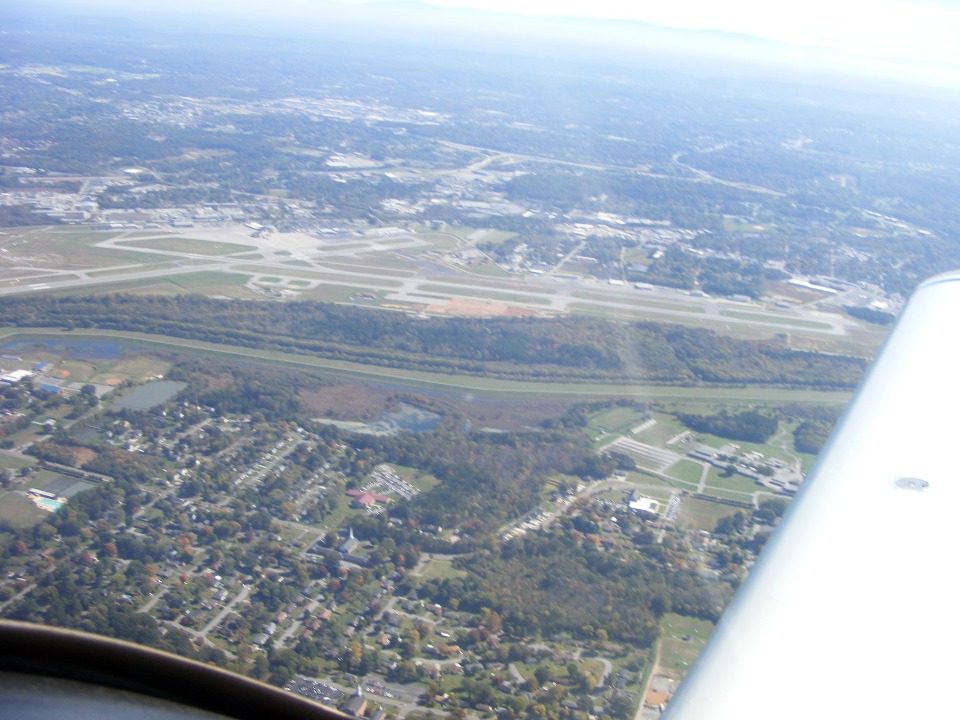
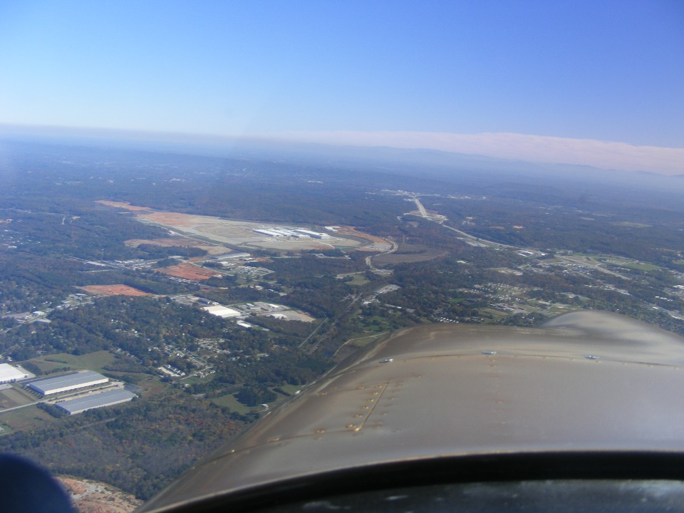
We crossed over the airport to get on the East side of the approach/departure
flight path before heading to a nearby lakeside resort area where my friend wanted to take
some aerial photos. I took this second shot of the airport with a point & shoot
method out the right side window. The camera had set the contrast to make the wing
look good. I did some post processing to make the ground terrain look good.
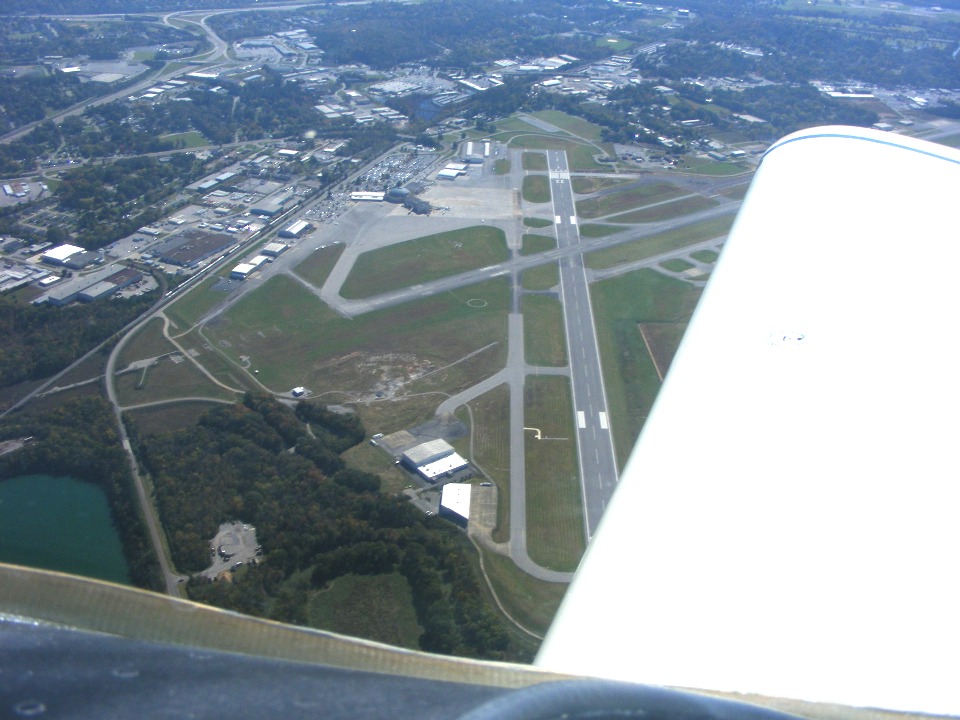
There has been a lot of interest in the new Volkswagen assembly plant being
constructed here in Chattanooga. You can see the location near Interstate 75 at what
was an old military ammunition plant years ago. The area was cleaned up and the
ground leveled out to accept these new facilities that will be building VW's here in the
USA in a year or so. I-75 is beyond the nose of the airplane disappearing toward the
northeast toward Cleveland and Knoxville, Tennessee. That cloud bank in the distance
is the front that passed here last night moving southeast.
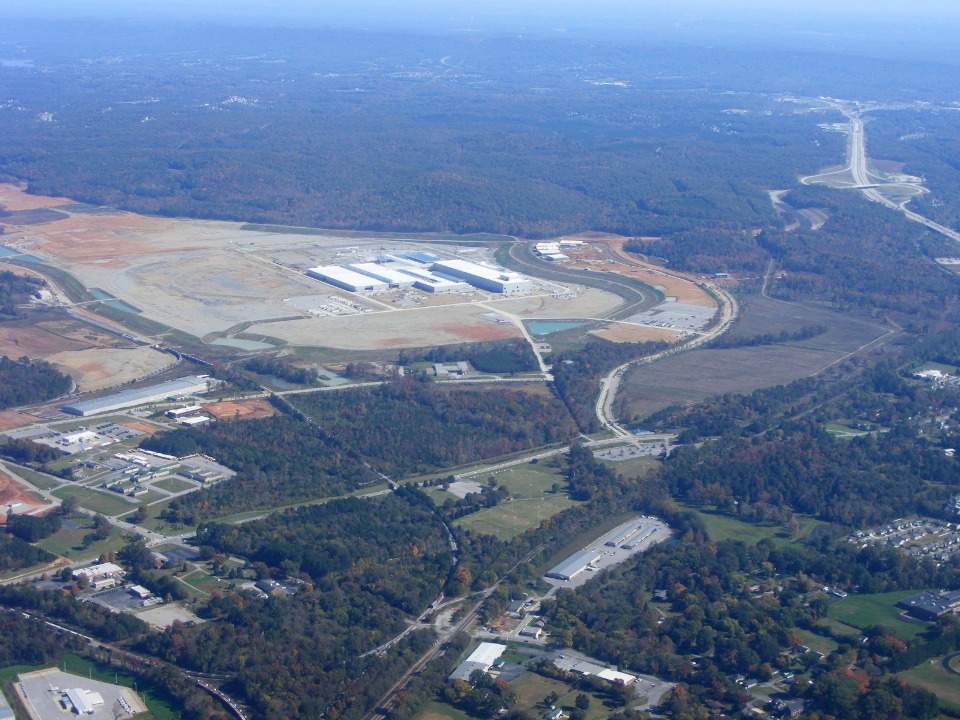
This closer photo shows things better at the VW construction site.
Here is a GPS overlay map showing the tour today in the 1.2 hours of flight
time. The flight started west toward South Pittsburg, then followed the Tennessee
River back toward the city. A turn to the south put Lookout Mountain the right side
of the airplane. We then turned north across the city, past the airport and up to
the Harrison area to fly over a lakeside resort for some photos taken by my friend with
his film camera. The flight then went past the Collegedale Airport and down to
Dalton for a flight around my friend's home and the new Dalton High School a block away.
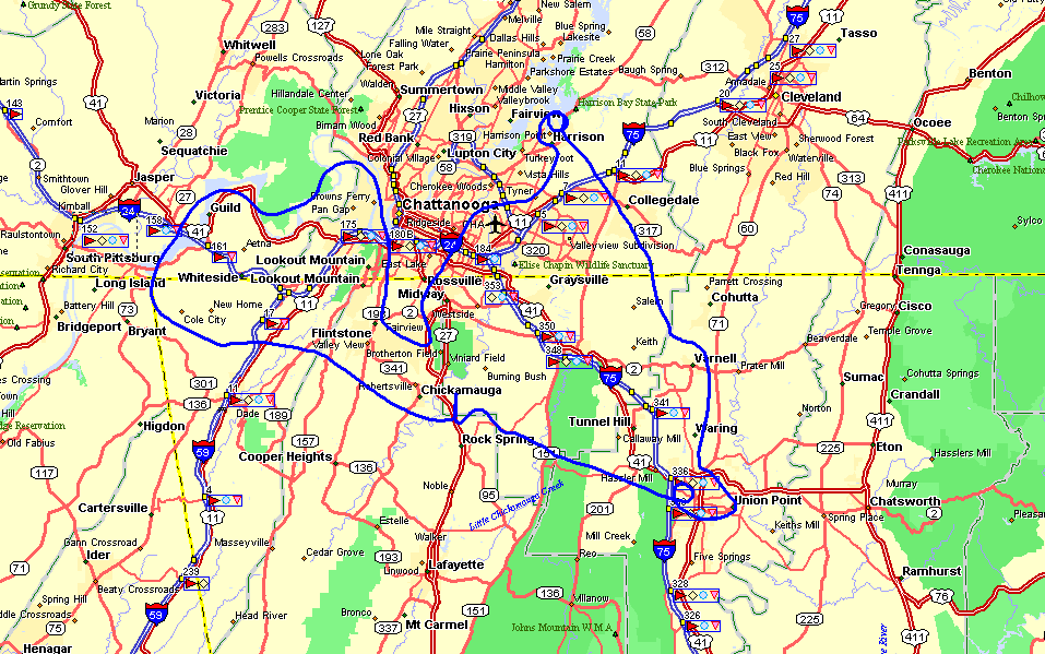
As you can see above the flight begins and ends at "Chickamauga International
Airport", a.k.a. Folks Field. The surface winds today were light and variable.
The takeoff was toward the south and the landing was from the south. I
apologize for not taking a photo of my friend when the airplane was out in the sun on the
ramp. When he gets his film developed, I will see how his pictures turned out.
One other thing to note today, one of the wheels on the hangar door failed today with the two pieces falling to the ground when I began to lower the door after getting the airplanes out on the ramp. I left the door up and when I returned I showed the two halves of the wheel to Wendell. The door is over 20 years old. He went off to get a pair of new wheels at the nearby Tractor Supply store. My friend and I went out for a late lunch nearby.
The Hobbs meter now shows 281.6 hours total time for "The Enterprise". I will be traveling back from Denver next Saturday. If I see anything worth photographs during the week on my day job, I will post them when able, or next Sunday when I am back at home.
| CLICK HERE for PAGE 313 | Return to MAIN MENU. |