
May / June 2022 Vacation Day 4 · · PAGE 8.
May 26. 2022: Texas and New Mexico are both working to improve US 285 and it shows here
at the state line entering New Mexico. The pavement changes as it does in
a lot of places like county lines and state lines. That sign at the right
side of this photo below mentions a State Line compressor station 2.6 miles
east, probably part of a pipe line. I would expect both states may erect
tourist signs when the construction is completed.
This oil drilling rig was set up about 5 miles north of the Texas / New
Mexico state line when the Google Earth photo vehicle passed this way in
November 2021 and captured this image.

A left turn here on US 62 will take us southwest from the city of
Carlsbad, NM toward our motel for tonight and tomorrow toward Carlsbad Caverns
and then to El Paso, Texas and westbound.
We have two motels to choose for pet friendly rooms, Motel 6 and Days Inn
are close together on US 62 south of the main part of the city. We stayed
at Motel 6. 
I went to Wal-Mart to fill up the gas tank of the Chevy. I pulled
into the Wal-Mart parking lot and discovered the Murphy Express was not
connected to the big parking lot. I had to get out on the main road and
come to the north side the gas station to get fuel. Trying to jump the
curb is NOT a good idea. The price in this image from November 2021 was
lower than the $4.079 per gallon I paid on the morning of May 26, 2022.
This was the end of DAY 4 before our next tourist adventure tomorrow morning.

May / June 2022 Vacation Day 5 · · PAGE 8.
May 27, 2022: Our Western Tour resumes at Motel 6 seen above going south on us 62
toward the best known tourist location in southeast New Mexico. This is the first sign for southbound US 62 traffic going to Carlsbad
Caverns located in the Guadalupe mountain range.

This is White's City, a place where New Mexico state route 7 connects with
US 62. It is less than 7 miles to the parking area and visitors center for
Carlsbad Caverns at the top of the mountain following route 7. Tourists
can spend hours there following the walking path down into the natural cave entrance to see
the formations created by millions of years of dripping water. This
image also shows the many airliner contrails going to and from Southern
California and maybe a few to Hawaii. The Guadalupe mountain range seen
here has the highest mountains in Texas. US 62 goes south of the mountains
before heading west to El Paso, Texas.

This place has the usual souvenir shops, a grocery store for campers, and a post
office.

Campers register here to pay their fees. The blue signs block the
grocery store sign. The post cards purchased in the gift shop can be
mailed from the post office seen here.

This sign is located at the edge of the national park boundary with the
visitor center 7 miles from here.

Route 7 follows the path of this wash between ridges.

This sign is at the edge of the parking area at the top of the mountain near the visitor's
center. That last mountain in the haze is the south end of the Guadalupe
mountain range. US 62 passes that location on the way to El Paso where US 62
ends at the border with Mexico. The northern end of US 62 is in the city
of Niagara Falls on the border with Canada.

Here is a sign I was glad to see. They have a kennel where Chase can
stay inside where it is air-conditioned while Linda and I explore the caverns for
about two hours. The sign below points to the Kennel Service which I had
called before we began our trip west. We put the bed for Linda's dog
"Chase" in the cage along with his food and water. He was
barking loudly when we left the kennel room. I first visited this National Park alone while on a
company trip in the fall of 1978. I was driving a company truck towing a
portable satellite antenna on a tandem axle trailer on my way to the Anaheim
Convention Center across the street from Disneyland in California.

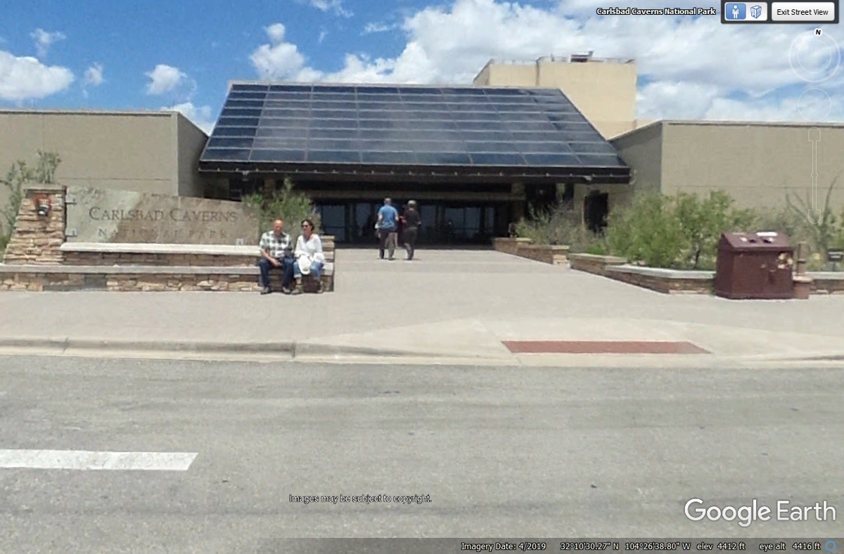
This is the main entrance to the visitor center. The tour of the
caverns starts here. I will be taking my own photos along the trail to the
caverns below.
My first photo shows this amphitheater located at the natural opening to the cave and the
caverns below. This place is where visitors come to see
millions of bats take flight at sunset to hunt airborne insects for food. The bats squeak
high frequency sound waves to find their prey in flight. The batteries in
my digital camera died as I tried to take the photo below. I had to walk
back to car to get fresh batteries.

Linda took this similar image while I was gone to get fresh batteries.

Linda snapped this photo of the natural entrance to the cave.

I used her camera to capture this image on the next lower switchback level
descending into the natural opening to the Caverns. She is carrying that
coat since the temperature further down in the cave is only 56 degrees F.

We stopped at the same Stalactite to take similar photos. Here is
Linda's camera photo that I snapped for her.

The trail winds its way past stalactite formations with low ambient
lighting to see the details. The flash from my camera illuminates details
that are not visible with low light levels in the caverns. The handrails
are all along the paths as some places can be wet from the dripping water that
creates these formations. My camera has a viewfinder that helps to frame
the desired image before taking the shot.

Linda walked along with me for quite a while until her knees got weak and
she had to sit down on a bench on the trail. A park ranger had come by our
location well before I snapped this photo. One of the other people walking
down the trail behind us mentioned seeing a location not far back up the trail
from this location to summon help from the park rangers. She went there
and pushed the help button. Less than five minutes later, the ranger that
passed us came walking back up the trail to the location seen in this
image. She has a radio that works with hidden antennas along the trail and
summoned another staff member who came down with an electric cart to take Linda
back along the trail to the welcome station at the top of the mountain
trail. He mentioned that I could continue down the trail to the lowest
part of the cave where elevators go up to the welcome station 750 feet above at
the surface. He mentioned it should take me about 30 minutes to get to the
elevator location from this location where he rescued my wife Linda.

I continued down the trail holding the hand rails all the way down.
This formation is called "Mouth of the Whale" since it resembles the
filtering mouth of the Blue Baleen Whale. I used the telephoto lens and
the flash from my camera to get this image below. A low power flood lamp
is there also.

I did not take any additional photos in the cave as I went down to the bottom and the elevators that go up to the welcome center. I met a number of people along the way. I came to the area one of the rangers mentioned where the motorized cart could not go. There was a place that was too narrow for the cart, as the steps there were strictly for walking. It was about 30 minutes when I was back at the welcome area at the top of the mountain. Linda was glad to see me. She bought some souvenirs and a DVD about the bat flight that happens every evening.
We parked in this row of spaces as it was near the Kennels on the south
side of the main building. We paid the claim check inside and were
re-united with our dog CHASE and quickly gave him the affection he needs and a
cool drink of water as we started down the mountain from the visitors center in
her Chevy Equinox.

Here is a Google Earth view about halfway down the backside of the
mountain. This is route 7 we used to get to the top of the mountain.

After leaving Carlsbad Caverns National Park, on US 62, about one quarter
mile south of State route 7 is this highway sign and a closer view of the south
end of the Guadalupe Mountains. This part of US 62 is somewhat lonely
after the town of Carlsbad, NM. There is a BLUE road sign ahead with
important information.

A FULL fuel tank is a good idea for the road ahead! The next gas
station is 145 miles from here. It is also a good idea to have drinking
water and some food.

Here is the ZERO mile marker for US 62 at the Texas State Line with New
Mexico in this
Google Earth image from June 2019. The pavement changes here as it did
when we entered New Mexico yesterday while we were heading to the city of
Carlsbad only with no road construction in this image.

There is still plenty of empty highway ahead to be traveled on US 62
heading toward El Paso, Texas.

This is the Pine Spring Safety Rest Area located about 9 miles south of
the Texas/New Mexico state line on US 62/US 180 as the routes are running this
highway together.

The highest mountain peaks are here at the south end of the Guadalupe
Mountain Range. The tallest peak is El Capitan.

The Google Earth image of the sign for the Frijole Ranch was better
illuminated by sunlight looking going north on US 62. The sign on the
southbound side of the highway was in shadow.

When I reached the location above on US 62 using Google Earth, I started
looking around and found the hiking trail to the monument at the top of
Guadalupe Peak seen in the image below where I selected an image looking West as
we will be following US 62 in that direction. I was glad to see Google
Earth had used their backpack camera rig up here.

Here is the southern boundary to Guadalupe Mountains National Park as seen
by northbound travelers on US 62.

This image from Google Earth is looking west from US 62 showing El
Capitan.

Linda took this photo from the south end of the roadside rest area seen in
the image above. This peak is close to the highway, whereas the large peak
in the background shows El Capitan which is the tallest point in Texas.

I had a trip to LOE5, a gathering of Van's RV builders at the Donna Ana
Airport near the town of Santa Teresa in southern New
Mexico west of the Rio Grand River. I snapped this photo in October 16,
2005 flying east showing both peaks at the south end of the Guadalupe
Mountains. When I flew past this point heading west October 14, 2005,
there were clouds obscuring the top of the mountain. This image shows more
details when I was returning East on the way back home near East Ridge,
Tennessee.

| NEW MEXICO and WESTWARD - PAGE9 | RETURN TO WESTERN TOUR INDEX PAGE |